
Topografische kaart Springdale
Klik op de kaart om de hoogte weer te geven.
Over deze kaart
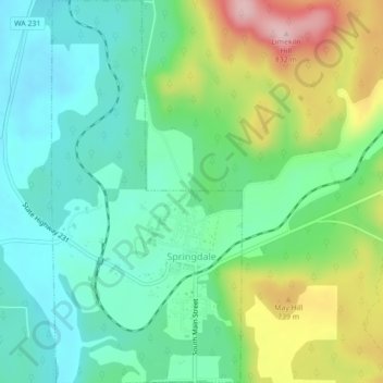
Naam: Topografische kaart Springdale, hoogte, reliëf.
Locatie: Springdale, Stevens County, Washington, United States (48.04844 -117.75785 48.07768 -117.73607)
Gemiddelde hoogte: 656 m
Minimale hoogte: 582 m
Maximale hoogte: 818 m
Andere topografische kaarten
Klik op een kaart om zijn topografie, zijn hoogte en zijn reliëf te bekijken.
Ford
United States > Washington > Stevens County
Ford is located in a mountainous area at the base of Happy Hill, which rises more than 600 feet immediately to the southeast of the community. The northeast–southwest trending Walkers Prairie and valley floor along which Chamokane Creek flows is relatively flat and at an elevation of between 1,700 and 1,800…
Gemiddelde hoogte: 577 m