
Topografische kaart Laramie
Interactieve kaart
Klik op de kaart om de hoogte weer te geven.
Laramie
Laramie is on a high plain between two mountain ranges, the Snowy Range, about 30 miles (48 km) to the west, and the Laramie Range, 7 miles (11 km) to the east. The city's elevation above sea level is approximately 7,165 feet (2,184 m). The Laramie River runs through Laramie toward its confluence with the North Platte River east of the Laramie Range.
Over deze kaart
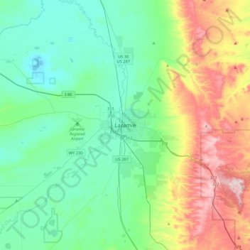
Naam: Topografische kaart Laramie, hoogte, reliëf.
Locatie: Laramie, Albany County, Wyoming, 82070, United States (41.15137 -105.75110 41.47137 -105.43110)
Gemiddelde hoogte: 2.299 m
Minimale hoogte: 2.133 m
Maximale hoogte: 2.744 m