
Topografische kaart Southbury
Interactieve kaart
Klik op de kaart om de hoogte weer te geven.
Over deze kaart
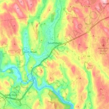
Naam: Topografische kaart Southbury, hoogte, reliëf.
Gemiddelde hoogte: 144 m
Minimale hoogte: 25 m
Maximale hoogte: 284 m
Andere topografische kaarten
Klik op een kaart om zijn topografie, zijn hoogte en zijn reliëf te bekijken.
Seymour
United States > Connecticut > Naugatuck Valley COG
Seymour, Naugatuck Valley COG, Connecticut, 06483, United States
Gemiddelde hoogte: 114 m
Pondside
United States > Connecticut > Naugatuck Valley COG > Cheshire
Pondside, Cheshire, Naugatuck Valley COG, Connecticut, 06451, United States
Gemiddelde hoogte: 71 m
Middlebury
United States > Connecticut > Naugatuck Valley COG
Middlebury, Naugatuck Valley COG, Connecticut, 06762, United States
Gemiddelde hoogte: 192 m
Allentown
United States > Connecticut > Naugatuck Valley COG > Plymouth
Allentown, Plymouth, Naugatuck Valley COG, Connecticut, 06786, United States
Gemiddelde hoogte: 244 m
Thomaston
United States > Connecticut > Naugatuck Valley COG
Thomaston, Naugatuck Valley COG, Connecticut, 06787, United States
Gemiddelde hoogte: 213 m