
Topografische kaart Banggi Island
Interactieve kaart
Klik op de kaart om de hoogte weer te geven.
Over deze kaart
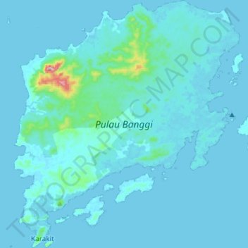
Naam: Topografische kaart Banggi Island, hoogte, reliëf.
Locatie: Banggi Island, Kudat, Kudat Division, Sabah, Malaysia (7.10037 117.05402 7.36281 117.29496)
Gemiddelde hoogte: 21 m
Minimale hoogte: 0 m
Maximale hoogte: 487 m
Banggi Island (Malay: Pulau Banggi) is located within the Kudat Division of Sabah in Malaysia. With an area of 440.7 square kilometres, it is the largest island in Malaysia followed by Bruit Island, Langkawi Island and Penang Island. It is located off the northern coast of Sabah near Marudu Bay. The highest elevation on the island is Bukit Sinambung with height of 529 metres. As of 2016, it has an estimated population of 30,000. Banggi's largest settlement is Limbuak. In 2014, a new township was proposed to be built in the island. The island is also part of the gazetted area of Tun Mustapha Marine Park.
Andere topografische kaarten
Klik op een kaart om zijn topografie, zijn hoogte en zijn reliëf te bekijken.
Kg. Tinangol
Kg. Tinangol, Kudat, Kudat Division, Sabah, Malaysia
Gemiddelde hoogte: 75 m
The Tip of Borneo
The Tip of Borneo, Kudat, Kudat Division, Sabah, Malaysia
Gemiddelde hoogte: 3 m