
Topografische kaart Coker
Interactieve kaart
Klik op de kaart om de hoogte weer te geven.
Over deze kaart
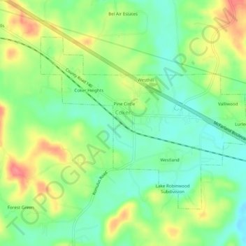
Naam: Topografische kaart Coker, hoogte, reliëf.
Locatie: Coker, Tuscaloosa County, Alabama, United States (33.23010 -87.70394 33.25829 -87.65585)
Gemiddelde hoogte: 68 m
Minimale hoogte: 38 m
Maximale hoogte: 112 m
Andere topografische kaarten
Klik op een kaart om zijn topografie, zijn hoogte en zijn reliëf te bekijken.
Tuscaloosa
United States > Alabama > Tuscaloosa County
Tuscaloosa, Tuscaloosa County, Alabama, United States
Gemiddelde hoogte: 98 m
Little Sandy
United States > Alabama > Tuscaloosa County
Little Sandy, Tuscaloosa County, Alabama, United States
Gemiddelde hoogte: 72 m
Bull City
United States > Alabama > Tuscaloosa County
Bull City, Tuscaloosa County, Alabama, United States
Gemiddelde hoogte: 161 m
Northbrook
United States > Alabama > Tuscaloosa County > Northport
Northbrook, Northport, Tuscaloosa County, Alabama, 35476, United States
Gemiddelde hoogte: 70 m
Peach Grove
United States > Alabama > Tuscaloosa County > Tuscaloosa
Peach Grove, Tuscaloosa, Tuscaloosa County, Alabama, 35405, United States
Gemiddelde hoogte: 109 m
Carmel Bay
United States > Alabama > Tuscaloosa County
Carmel Bay, Tuscaloosa County, Alabama, 35475, United States
Gemiddelde hoogte: 82 m
East Lake
United States > Alabama > Tuscaloosa County > Tuscaloosa > East Lake
East Lake, Tuscaloosa, Tuscaloosa County, Alabama, 35405, United States
Gemiddelde hoogte: 110 m
Northport
United States > Alabama > Tuscaloosa County > Northport
Northport, Tuscaloosa County, Alabama, United States
Gemiddelde hoogte: 89 m
Brookwood
United States > Alabama > Tuscaloosa County
Brookwood, Tuscaloosa County, Alabama, United States
Gemiddelde hoogte: 150 m