
Topografische kaart Sumner Lake State Park
Interactieve kaart
Klik op de kaart om de hoogte weer te geven.
Over deze kaart
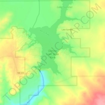
Naam: Topografische kaart Sumner Lake State Park, hoogte, reliëf.
Gemiddelde hoogte: 1.311 m
Minimale hoogte: 1.262 m
Maximale hoogte: 1.364 m
The park features a large 4,500-acre (18 km2) reservoir on the Pecos River, created in 1939 by the Sumner Dam of the United States Bureau of Reclamation. The reservoir is home to various fish species including largemouth bass, catfish, crappie and walleye. The park elevation is 4,300 feet (1,300 m) above sea level. With its campground, expansive views of the sky, and its distance from other cities, Sumner Lake State Park has a low level of light pollution, which makes the state park a great potential place for amateur astronomy.
Andere topografische kaarten
Klik op een kaart om zijn topografie, zijn hoogte en zijn reliëf te bekijken.
White Mesa
United States > New Mexico > De Baca County
White Mesa, De Baca County, New Mexico, United States
Gemiddelde hoogte: 1.348 m