
Topografische kaart Retil
Interactieve kaart
Klik op de kaart om de hoogte weer te geven.
Over deze kaart
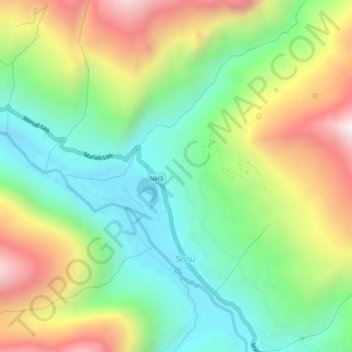
Naam: Topografische kaart Retil, hoogte, reliëf.
Locatie: Retil, Sissu, Lahul, Lahul and Spiti, Himachal Pradesh, India (32.45823 77.11107 32.49823 77.15107)
Gemiddelde hoogte: 3.418 m
Minimale hoogte: 2.982 m
Maximale hoogte: 4.114 m