
Topografische kaart Lawton
Interactieve kaart
Klik op de kaart om de hoogte weer te geven.
Over deze kaart
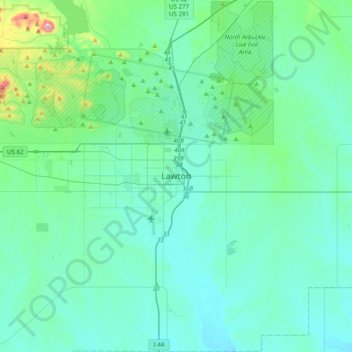
Naam: Topografische kaart Lawton, hoogte, reliëf.
Locatie: Lawton, Comanche County, Oklahoma, 73501, United States (34.44869 -98.55033 34.76869 -98.23033)
Gemiddelde hoogte: 361 m
Minimale hoogte: 305 m
Maximale hoogte: 747 m
Andere topografische kaarten
Klik op een kaart om zijn topografie, zijn hoogte en zijn reliëf te bekijken.
Academic Hights
United States > Oklahoma > Comanche County > Lawton
Academic Hights, Lawton, Comanche County, Oklahoma, United States
Gemiddelde hoogte: 348 m