
Doe een donatie
Rust jezelf uit voor je volgende avontuur:
Als Amazon-partner verdient deze site een commissie op in aanmerking komende aankopen, zonder extra kosten voor jou.
Topografische kaart Watertown
Klik op de kaart om de hoogte weer te geven.
Doe een donatie
Rust jezelf uit voor je volgende avontuur:
Als Amazon-partner verdient deze site een commissie op in aanmerking komende aankopen, zonder extra kosten voor jou.
Watertown
According to the United States Census Bureau, the city has a total area of 25.04 square miles (64.85 km2), of which 17.45 square miles (45.20 km2) is land and 7.59 square miles (19.66 km2) is water. Watertown sits on the Big Sioux River and two major lakes, Pelican Lake and Lake Kampeska. Most of Watertown also sits upon a short plateau. The elevation at Watertown Regional Airport is 1,745 feet.
Doe een donatie
Rust jezelf uit voor je volgende avontuur:
Als Amazon-partner verdient deze site een commissie op in aanmerking komende aankopen, zonder extra kosten voor jou.
Over deze kaart
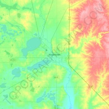
Naam: Topografische kaart Watertown, hoogte, reliëf.
Gemiddelde hoogte: 550 m
Minimale hoogte: 512 m
Maximale hoogte: 621 m
Doe een donatie
Rust jezelf uit voor je volgende avontuur:
Als Amazon-partner verdient deze site een commissie op in aanmerking komende aankopen, zonder extra kosten voor jou.