
Topografische kaart Frisco
Interactieve kaart
Klik op de kaart om de hoogte weer te geven.
Over deze kaart
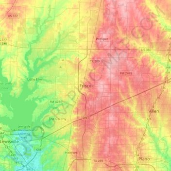
Naam: Topografische kaart Frisco, hoogte, reliëf.
Locatie: Frisco, Collin County, Texas, 75034, United States (32.99067 -96.98361 33.31067 -96.66361)
Gemiddelde hoogte: 191 m
Minimale hoogte: 133 m
Maximale hoogte: 246 m
When the Dallas area was being settled by American pioneers, many of the settlers traveled by wagon trains along the Shawnee Trail. This trail became the Preston Trail, and later Preston Road. With all this activity, the community of Lebanon was founded along this trail, and was granted a U.S. post office in 1860. In 1902, a line of the St. Louis-San Francisco Railway was being built through the area, and periodic watering stops were needed along the route for the steam locomotives. The current settlement of Lebanon was on the Preston Ridge, and was too high in elevation, so the watering stop was placed about 4 miles (6 km) to the west on lower ground. A community grew around this train stop. Some Lebanon residents moved their houses to the new community on logs. The new town was originally named Emerson, but the U.S. Postal Service rejected the name as too similar to another community, Emberson, in Lamar County. In 1904, the town's residents chose "Frisco City" in honor of the St. Louis–San Francisco Railway. This name was later shortened to Frisco.
Andere topografische kaarten
Klik op een kaart om zijn topografie, zijn hoogte en zijn reliëf te bekijken.
Panther Creek
United States > Texas > Collin County > Frisco
Panther Creek, Frisco, Collin County, Texas, 75033, United States
Gemiddelde hoogte: 197 m