
Topografische kaart Świebodzin
Interactieve kaart
Klik op de kaart om de hoogte weer te geven.
Over deze kaart
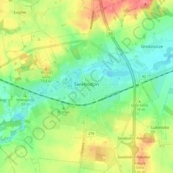
Naam: Topografische kaart Świebodzin, hoogte, reliëf.
Gemiddelde hoogte: 97 m
Minimale hoogte: 70 m
Maximale hoogte: 135 m
The town's name derives from the Polish personal name Świeboda, related to swoboda meaning "freedom". The area was part of Poland since the creation of the state in the 10th century. As a result of the fragmentation of Poland, it initially was part of Greater Poland, and later it was part of Silesia. The earliest historical records which mention Sebusianis, Sipusius Silesius, Suebosian, Soebosian, Suebusianus for today's Świebodzin date from the beginning of the 14th century, when the area belonged to the Lower Silesian Polish-ruled Duchy of Głogów. The town sprang up at the intersection of the old trade routes linking Silesia with Pomerania and a branch of the route running from Lusatia to Poznań in Greater Poland and further to Pomerelia. Initially, the town was probably a defensive fortification, built on the western banks of Lake Zamecko at a slight elevation. The town wall was ringed by settlements, which were much later incorporated into the city itself.