
Topografische kaart Souris
Interactieve kaart
Klik op de kaart om de hoogte weer te geven.
Over deze kaart
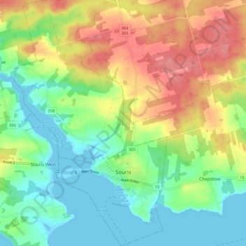
Naam: Topografische kaart Souris, hoogte, reliëf.
Locatie: Souris, Kings County, Prince Edward Island, Canada (46.33544 -62.29540 46.40542 -62.22013)
Gemiddelde hoogte: 33 m
Minimale hoogte: -3 m
Maximale hoogte: 79 m
Andere topografische kaarten
Klik op een kaart om zijn topografie, zijn hoogte en zijn reliëf te bekijken.
Albion
Canada > Prince Edward Island > Kings County
Albion, Town of Three Rivers, Kings County, Prince Edward Island, Canada
Gemiddelde hoogte: 13 m
Sturgeon
Canada > Prince Edward Island > Kings County
Sturgeon, Town of Three Rivers, Kings County, Prince Edward Island, Canada
Gemiddelde hoogte: 12 m
St. Patrick Road
Canada > Prince Edward Island > Kings County
St. Patrick Road, Kings County, Prince Edward Island, Canada
Gemiddelde hoogte: 45 m
Georgetown
Canada > Prince Edward Island > Kings County
Georgetown, Town of Three Rivers, Kings County, Prince Edward Island, Canada
Gemiddelde hoogte: 9 m
Maitland Flat
Canada > Prince Edward Island > Kings County > DeGros Marsh
Maitland Flat, DeGros Marsh, Town of Three Rivers, Kings County, Prince Edward Island, Canada
Gemiddelde hoogte: 5 m
Cardigan
Canada > Prince Edward Island > Kings County > Cardigan
Cardigan, Town of Three Rivers, Kings County, Prince Edward Island, Canada
Gemiddelde hoogte: 27 m
Lower Montague
Canada > Prince Edward Island > Kings County > Lower Montague
Lower Montague, Town of Three Rivers, Kings County, Prince Edward Island, C0A 1R0, Canada
Gemiddelde hoogte: 15 m