
Topografische kaart Fort Scott
Interactieve kaart
Klik op de kaart om de hoogte weer te geven.
Over deze kaart
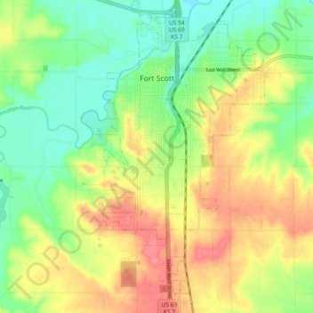
Naam: Topografische kaart Fort Scott, hoogte, reliëf.
Locatie: Fort Scott, Bourbon County, Kansas, 66701, United States (37.78583 -94.73034 37.85780 -94.67602)
Gemiddelde hoogte: 266 m
Minimale hoogte: 235 m
Maximale hoogte: 303 m
Fort Scott is located at 37°50′7″N 94°42′7″W / 37.83528°N 94.70194°W / 37.83528; -94.70194 (37.835180, −94.702015) at an elevation of 846 feet (258 m). It lies on the Osage Plains on the south side of the Marmaton River. Located at the intersection of U.S. Routes 54 and 69 in southeast Kansas, Fort Scott is approximately 54 miles (87 km) north of Joplin, Missouri, 92 miles (148 km) south of Kansas City, and 143 miles (230 km) east of Wichita.
Andere topografische kaarten
Klik op een kaart om zijn topografie, zijn hoogte en zijn reliëf te bekijken.
Garland
United States > Kansas > Bourbon County
Garland, Bourbon County, Kansas, 66741, United States
Gemiddelde hoogte: 259 m
Redfield
United States > Kansas > Bourbon County
Redfield, Bourbon County, Kansas, United States
Gemiddelde hoogte: 263 m
Hammond
United States > Kansas > Bourbon County
Hammond, Bourbon County, Kansas, United States
Gemiddelde hoogte: 266 m
Marmaton
United States > Kansas > Bourbon County
Marmaton, Bourbon County, Kansas, United States
Gemiddelde hoogte: 266 m
Mapleton
United States > Kansas > Bourbon County
Mapleton, Bourbon County, Kansas, United States
Gemiddelde hoogte: 267 m
Berlin
United States > Kansas > Bourbon County
Berlin, Bourbon County, Kansas, United States
Gemiddelde hoogte: 293 m
Devon
United States > Kansas > Bourbon County
Devon, Bourbon County, Kansas, United States
Gemiddelde hoogte: 268 m
Harding
United States > Kansas > Bourbon County
Harding, Bourbon County, Kansas, 66764, United States
Gemiddelde hoogte: 267 m
Pawnee Station
United States > Kansas > Bourbon County
Pawnee Station, Bourbon County, Kansas, United States
Gemiddelde hoogte: 296 m
Xenia
United States > Kansas > Bourbon County
Xenia, Bourbon County, Kansas, United States
Gemiddelde hoogte: 295 m
Bronson
United States > Kansas > Bourbon County
Bronson, Bourbon County, Kansas, United States
Gemiddelde hoogte: 323 m
Fulton
United States > Kansas > Bourbon County
Fulton, Bourbon County, Kansas, 66738, United States
Gemiddelde hoogte: 252 m
Barnesville
United States > Kansas > Bourbon County
Barnesville, Bourbon County, Kansas, United States
Gemiddelde hoogte: 252 m
Godfrey
United States > Kansas > Bourbon County
Godfrey, Bourbon County, Kansas, United States
Gemiddelde hoogte: 287 m
Hiattville
United States > Kansas > Bourbon County
Hiattville, Bourbon County, Kansas, United States
Gemiddelde hoogte: 293 m
Porterville
United States > Kansas > Bourbon County
Porterville, Bourbon County, Kansas, United States
Gemiddelde hoogte: 317 m
Uniontown
United States > Kansas > Bourbon County
Uniontown, Bourbon County, Kansas, United States
Gemiddelde hoogte: 275 m