
Topografische kaart Boulder
Interactieve kaart
Klik op de kaart om de hoogte weer te geven.
Over deze kaart
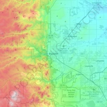
Naam: Topografische kaart Boulder, hoogte, reliëf.
Locatie: Boulder, Boulder County, Colorado, 80306, United States (39.85499 -105.43055 40.17499 -105.11055)
Gemiddelde hoogte: 1.977 m
Minimale hoogte: 1.495 m
Maximale hoogte: 3.187 m
Boulder is located at the base of the foothills of the Rocky Mountains, at an elevation of 5,430 feet (1,655 m) above sea level. Boulder is 25 miles (40 km) northwest of the Colorado State Capitol in Denver. It is home of the main campus of the University of Colorado, the state's largest university.
Andere topografische kaarten
Klik op een kaart om zijn topografie, zijn hoogte en zijn reliëf te bekijken.
National Center for Atmospheric Research
United States > Colorado > Boulder County > Boulder
National Center for Atmospheric Research, Stony Hill Road, Boulder, Boulder County, Colorado, 80305, United States
Gemiddelde hoogte: 1.816 m