
Topografische kaart Sainte-Marguerite
Interactieve kaart
Klik op de kaart om de hoogte weer te geven.
Over deze kaart
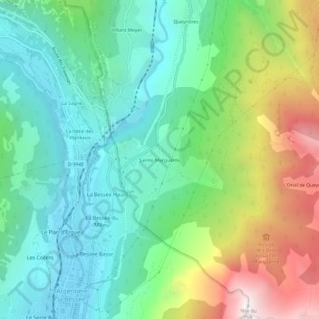
Naam: Topografische kaart Sainte-Marguerite, hoogte, reliëf.
Gemiddelde hoogte: 1.453 m
Minimale hoogte: 970 m
Maximale hoogte: 2.518 m
Andere topografische kaarten
Klik op een kaart om zijn topografie, zijn hoogte en zijn reliëf te bekijken.
Ratière
France > Provence-Alpes-Côte d'Azur > Hautes-Alpes > Saint-Martin-de-Queyrières
Ratière, Saint-Martin-de-Queyrières, Briançon, Hautes-Alpes, Provence-Alpes-Côte d'Azur, France métropolitaine, 05120, France
Gemiddelde hoogte: 1.723 m
Roche Baron
France > Provence-Alpes-Côte d'Azur > Hautes-Alpes > Saint-Martin-de-Queyrières
Roche Baron, Saint-Martin-de-Queyrières, Briançon, Hautes-Alpes, Provence-Alpes-Côte d'Azur, France métropolitaine, 05120, France
Gemiddelde hoogte: 1.512 m
La Salcette
France > Provence-Alpes-Côte d'Azur > Hautes-Alpes > Saint-Martin-de-Queyrières
La Salcette, Saint-Martin-de-Queyrières, Briançon, Hautes-Alpes, Provence-Alpes-Côte d'Azur, France métropolitaine, 05120, France
Gemiddelde hoogte: 1.834 m