
Topografische kaart Kairakau Beach
Interactieve kaart
Klik op de kaart om de hoogte weer te geven.
Over deze kaart
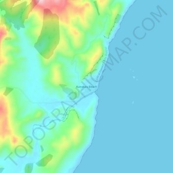
Naam: Topografische kaart Kairakau Beach, hoogte, reliëf.
Gemiddelde hoogte: 46 m
Minimale hoogte: 0 m
Maximale hoogte: 248 m
Andere topografische kaarten
Klik op een kaart om zijn topografie, zijn hoogte en zijn reliëf te bekijken.
Waipawa Hill
New Zealand > Hawke's Bay > Central Hawke's Bay District
Waipawa Hill, Central Hawke's Bay District, Hawke's Bay, 4210, New Zealand
Gemiddelde hoogte: 253 m
Waipukurau
New Zealand > Hawke's Bay > Central Hawke's Bay District
Waipukurau, Central Hawke's Bay District, Hawke's Bay, 4200, New Zealand
Gemiddelde hoogte: 153 m
Otane
New Zealand > Hawke's Bay > Central Hawke's Bay District
Otane, Central Hawke's Bay District, Hawke's Bay, 4202, New Zealand
Gemiddelde hoogte: 120 m
Ongaonga
New Zealand > Hawke's Bay > Central Hawke's Bay District
Ongaonga, Central Hawke's Bay District, Hawke's Bay, New Zealand
Gemiddelde hoogte: 206 m