
Topografische kaart Shag Harbour
Interactieve kaart
Klik op de kaart om de hoogte weer te geven.
Over deze kaart
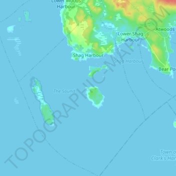
Naam: Topografische kaart Shag Harbour, hoogte, reliëf.
Gemiddelde hoogte: 3 m
Minimale hoogte: -1 m
Maximale hoogte: 45 m
Andere topografische kaarten
Klik op een kaart om zijn topografie, zijn hoogte en zijn reliëf te bekijken.
East Sable River
Canada > Nova Scotia > Shelburne County
East Sable River, Municipality of the District of Shelburne, Shelburne County, Nova Scotia, B0T 1V0, Canada
Gemiddelde hoogte: 17 m
Clam Creek
Canada > Nova Scotia > Shelburne County > Cape Negro
Clam Creek, Cape Negro, Municipality of the District of Barrington, Shelburne County, Nova Scotia, B0W 1K0, Canada
Gemiddelde hoogte: 2 m
Shag Harbour Pond
Canada > Nova Scotia > Shelburne County > Lower Shag Harbour
Shag Harbour Pond, Lower Shag Harbour, Municipality of the District of Barrington, Shelburne County, Nova Scotia, B0W 3B0, Canada
Gemiddelde hoogte: 11 m
Sable River
Canada > Nova Scotia > Shelburne County
Sable River, Municipality of the District of Shelburne, Shelburne County, Nova Scotia, B0T 1J0, Canada
Gemiddelde hoogte: 50 m
Brook Islands
Canada > Nova Scotia > Shelburne County > Shag Harbour
Brook Islands, Shag Harbour, Municipality of the District of Barrington, Shelburne County, Nova Scotia, B0W 3B0, Canada
Gemiddelde hoogte: 9 m