
Topografische kaart Canebrake
Interactieve kaart
Klik op de kaart om de hoogte weer te geven.
Over deze kaart
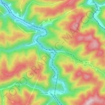
Naam: Topografische kaart Canebrake, hoogte, reliëf.
Gemiddelde hoogte: 607 m
Minimale hoogte: 447 m
Maximale hoogte: 774 m
Andere topografische kaarten
Klik op een kaart om zijn topografie, zijn hoogte en zijn reliëf te bekijken.
Worth
United States > West Virginia > McDowell County
Worth, McDowell County, West Virginia, 24858, United States
Gemiddelde hoogte: 731 m
Faraday
United States > West Virginia > McDowell County > Faraday
Faraday, McDowell County, West Virginia, 24601, United States
Gemiddelde hoogte: 639 m
Yerba
United States > West Virginia > McDowell County
Yerba, McDowell County, West Virginia, 24828, United States
Gemiddelde hoogte: 563 m
English
United States > West Virginia > McDowell County
English, McDowell County, West Virginia, 24813, United States
Gemiddelde hoogte: 558 m
Welch
United States > West Virginia > McDowell County
Welch, McDowell County, West Virginia, 24801, United States
Gemiddelde hoogte: 548 m