
Topografische kaart Pasighat
Interactieve kaart
Klik op de kaart om de hoogte weer te geven.
Over deze kaart
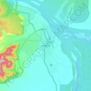
Naam: Topografische kaart Pasighat, hoogte, reliëf.
Locatie: Pasighat, Pasighat HQ, East Siang, Arunachal Pradesh, India (28.01897 95.29249 28.09897 95.37249)
Gemiddelde hoogte: 179 m
Minimale hoogte: 139 m
Maximale hoogte: 393 m
Pasighat is located at 28°04′N 95°20′E / 28.07°N 95.33°E / 28.07; 95.33. It has an average elevation of 153 metres or 502 feet. Pasighat has a typical lowland Northeast India humid subtropical climate (Köppen Cwa) a little too cool to qualify as a tropical monsoon climate (Am).