
Topografische kaart Jasło
Interactieve kaart
Klik op de kaart om de hoogte weer te geven.
Over deze kaart
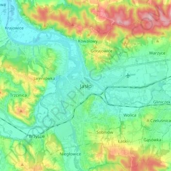
Naam: Topografische kaart Jasło, hoogte, reliëf.
Locatie: Jasło, Jasło County, Subcarpathian Voivodeship, Poland (49.71044 21.40176 49.78358 21.54169)
Gemiddelde hoogte: 265 m
Minimale hoogte: 216 m
Maximale hoogte: 378 m
Jasło [ˈjaswɔ] (listen) is a county town in south-eastern Poland with 36,641 inhabitants, as of 31 December 2012. It is situated in the Subcarpathian Voivodeship (since 1999), and it was previously part of Krosno Voivodeship (1975–1998). It is located in Lesser Poland, in the heartland of the Doły (Pits), and its average altitude is 320 metres above sea level, although there are some hills located within the confines of the city. The Patron Saint of the city is Saint Anthony of Padua.