
Topografische kaart Mount Apo
Interactieve kaart
Klik op de kaart om de hoogte weer te geven.
Over deze kaart
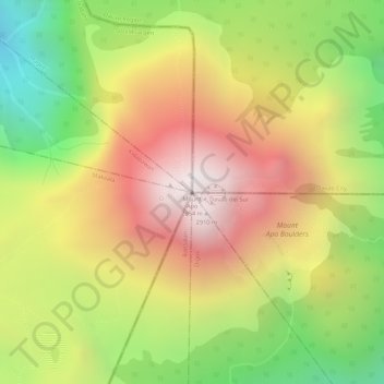
Naam: Topografische kaart Mount Apo, hoogte, reliëf.
Gemiddelde hoogte: 2.416 m
Minimale hoogte: 1.804 m
Maximale hoogte: 2.931 m
Mount Apo, also known locally as Apo Sandawa, is a large solfataric, dormant stratovolcano on the island of Mindanao, Philippines. With an elevation of 2,954 meters (9,692 ft) above sea level, it is the highest-mountain in the Philippine Archipelago, Mindanao and 24th-highest peak of an island on Earth. Located on the tripartite border of Davao City and Davao del Sur in the Davao Region, and Cotabato in Soccsksargen, Mount Apo is the most-prominent mountain in the Philippines. The peak overlooks from Davao City 45 kilometers (28 mi) to the northeast, Digos 25 kilometers (16 mi) to the southeast, and Kidapawan 20 kilometers (12 mi) to the west. It is a protected area and a Natural Park of the Philippines.
Andere topografische kaarten
Klik op een kaart om zijn topografie, zijn hoogte en zijn reliëf te bekijken.
New Bohol
Philippines > Davao del Sur > Bansalan
New Bohol, Bansalan, Davao del Sur, Davao Region, 8005, Philippines
Gemiddelde hoogte: 1.050 m
Managa
Philippines > Davao del Sur > Bansalan
Managa, Bansalan, Davao del Sur, Davao Region, 8005, Philippines
Gemiddelde hoogte: 376 m
Bansalan
Philippines > Davao del Sur > Bansalan
Bansalan, Davao del Sur, Davao Region, 8005, Philippines
Gemiddelde hoogte: 157 m