
Topografische kaart Cherokee Park
Interactieve kaart
Klik op de kaart om de hoogte weer te geven.
Over deze kaart
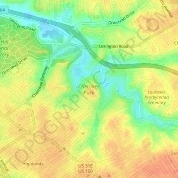
Naam: Topografische kaart Cherokee Park, hoogte, reliëf.
Gemiddelde hoogte: 159 m
Minimale hoogte: 134 m
Maximale hoogte: 175 m
Andere topografische kaarten
Klik op een kaart om zijn topografie, zijn hoogte en zijn reliëf te bekijken.
Shawneeland
United States > Kentucky > Jefferson County > Louisville
Shawneeland, Louisville, Jefferson County, Kentucky, 40211, United States
Gemiddelde hoogte: 138 m
Waverly Hills
United States > Kentucky > Jefferson County > Louisville
Waverly Hills, Louisville, Jefferson County, Kentucky, 40258, United States
Gemiddelde hoogte: 155 m
Parkland
United States > Kentucky > Jefferson County > Louisville
Parkland, Louisville, Jefferson County, Kentucky, 40211, United States
Gemiddelde hoogte: 139 m
Saint Matthews
United States > Kentucky > Jefferson County > Louisville
Saint Matthews, Louisville, Jefferson County, Kentucky, 40207, United States
Gemiddelde hoogte: 166 m
Cherokee Garden
United States > Kentucky > Jefferson County > Louisville
Cherokee Garden, Louisville, Jefferson County, Kentucky, 40041, United States
Gemiddelde hoogte: 164 m
Newburg
United States > Kentucky > Jefferson County > Louisville
Newburg, Louisville, Jefferson County, Kentucky, 40225, United States
Gemiddelde hoogte: 156 m
Louisville-Jefferson County (Balance)
United States > Kentucky > Jefferson County > Louisville
Louisville-Jefferson County (Balance), Louisville, Jefferson County, Kentucky, 40231, United States
Gemiddelde hoogte: 157 m
South Park
United States > Kentucky > Jefferson County > Louisville
South Park, Louisville, Jefferson County, Kentucky, 40118, United States
Gemiddelde hoogte: 149 m
Mirror Lakes
United States > Kentucky > Jefferson County > Louisville > Hopewell
Mirror Lakes, Hopewell, Louisville, Jefferson County, Kentucky, United States
Gemiddelde hoogte: 198 m
Falls of the Ohio State Park
United States > Kentucky > Jefferson County > Louisville
Falls of the Ohio State Park, Louisville, Jefferson County, Kentucky, United States
Gemiddelde hoogte: 135 m
Fern Creek
United States > Kentucky > Jefferson County > Louisville
Fern Creek, Louisville, Jefferson County, Kentucky, 40291, United States
Gemiddelde hoogte: 211 m
Bethany
United States > Kentucky > Jefferson County > Louisville
Bethany, Louisville, Jefferson County, Kentucky, 40272, United States
Gemiddelde hoogte: 141 m
Fairdale
United States > Kentucky > Jefferson County > Louisville
Fairdale, Louisville, Jefferson County, Kentucky, 40118, United States
Gemiddelde hoogte: 158 m