
Topografische kaart Koło
Interactieve kaart
Klik op de kaart om de hoogte weer te geven.
Over deze kaart
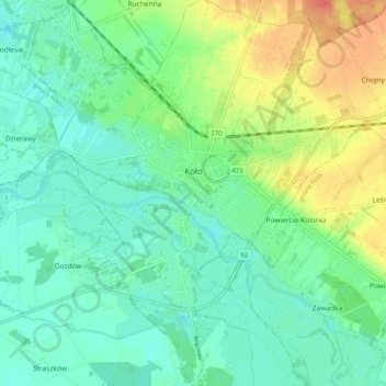
Naam: Topografische kaart Koło, hoogte, reliëf.
Locatie: Koło, Koło County, Greater Poland Voivodeship, Poland (52.16735 18.59196 52.22942 18.67953)
Gemiddelde hoogte: 100 m
Minimale hoogte: 84 m
Maximale hoogte: 133 m
Andere topografische kaarten
Klik op een kaart om zijn topografie, zijn hoogte en zijn reliëf te bekijken.
Dąbie
Poland > Greater Poland Voivodeship > Koło County > Dąbie > Dąbie
Dąbie, gmina Dąbie, Koło County, Greater Poland Voivodeship, 62-660, Poland
Gemiddelde hoogte: 103 m
Karszew
Poland > Greater Poland Voivodeship > Koło County > Karszew
Karszew, gmina Dąbie, Koło County, Greater Poland Voivodeship, 62-660, Poland
Gemiddelde hoogte: 106 m