
Topografische kaart Wetlina
Interactieve kaart
Klik op de kaart om de hoogte weer te geven.
Over deze kaart
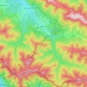
Naam: Topografische kaart Wetlina, hoogte, reliëf.
Gemiddelde hoogte: 857 m
Minimale hoogte: 570 m
Maximale hoogte: 1.235 m
The village is located near the source (springs) of the Weltinka river, a primary tributary of the Solinka river. South and west of the village are the Sękowa (1022 m) and Paprotna (1193 m) mountain peaks. East of the village are the range peaks of Połonina Wetlińska, with a maximum elevation of 1253 m.