
Topografische kaart Prads-Haute-Bléone
Interactieve kaart
Klik op de kaart om de hoogte weer te geven.
Over deze kaart
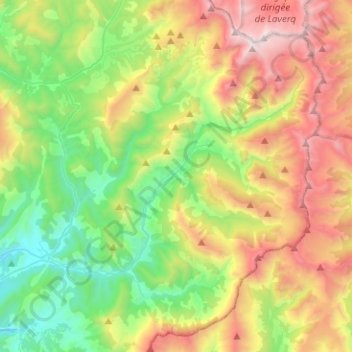
Naam: Topografische kaart Prads-Haute-Bléone, hoogte, reliëf.
Gemiddelde hoogte: 1.573 m
Minimale hoogte: 749 m
Maximale hoogte: 2.935 m
The municipality of Prads-Haute-Bléone extends over 16,500 hectares (41,000 acres), it is composed of nine hamlets ranging in elevation from 800 to 1 450 metres. The main settlement of Prads is at 1,048 metres (3,438 ft), and the highest peak is the Tête de l'Estrop at 2,961 metres (9,715 ft) in the Massif des Trois-Évêchés at the border with Méolans-Revel. This is also the highest summit of the Provence Alps and Prealps.