
Topografische kaart Hagerstown
Interactieve kaart
Klik op de kaart om de hoogte weer te geven.
Over deze kaart
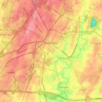
Naam: Topografische kaart Hagerstown, hoogte, reliëf.
Locatie: Hagerstown, Washington County, Maryland, United States (39.60003 -77.77309 39.67373 -77.67228)
Gemiddelde hoogte: 170 m
Minimale hoogte: 102 m
Maximale hoogte: 204 m
Hagerstown has a distinct topography, formed by stone ridges running from northeast to southwest through the center of town. Geography accordingly bounds its neighborhoods. These ridges consist of upper Stonehenge limestone. Many of the older buildings were built from this stone, which is easily quarried and dressed onsite. It whitens in weathering and the edgewise conglomerate and wavy laminae become distinctly visible, giving a handsome and uniquely "Cumberland Valley" appearance. Several of Hagerstown's churches are constructed of Stonehenge limestone. Its value and beauty as building rock may be seen particularly in St. John's Episcopal Church on West Antietam Street and the Presbyterian Church at the corner of Washington and Prospect Streets. Brick and concrete eventually displaced this native stone in the construction process.[6]
Andere topografische kaarten
Klik op een kaart om zijn topografie, zijn hoogte en zijn reliëf te bekijken.
Weverton
United States > Maryland > Washington County
Weverton, Washington County, Maryland, 21758, United States
Gemiddelde hoogte: 153 m
Hancock
United States > Maryland > Washington County
Hancock, Washington County, Maryland, United States
Gemiddelde hoogte: 167 m
Hancock
United States > Maryland > Washington County > Hancock > Hancock
Hancock, Washington County, Maryland, 21750, United States
Gemiddelde hoogte: 166 m
Keedysville
United States > Maryland > Washington County > Keedysville
Keedysville, Washington County, Maryland, United States
Gemiddelde hoogte: 129 m
Sharpsburg
United States > Maryland > Washington County
Sharpsburg, Washington County, Maryland, United States
Gemiddelde hoogte: 138 m