
Topografische kaart Sha Tin
Interactieve kaart
Klik op de kaart om de hoogte weer te geven.
Over deze kaart
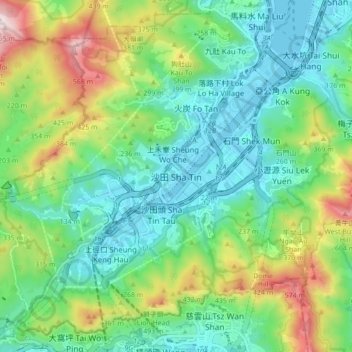
Naam: Topografische kaart Sha Tin, hoogte, reliëf.
Locatie: Sha Tin, Sha Tin District, New Territories, Hong Kong, China (22.34155 114.15047 22.42155 114.23047)
Gemiddelde hoogte: 196 m
Minimale hoogte: -3 m
Maximale hoogte: 662 m
Andere topografische kaarten
Klik op een kaart om zijn topografie, zijn hoogte en zijn reliëf te bekijken.
Kau To
China > Hong Kong > Sha Tin District
Kau To, Sha Tin District, New Territories, Hong Kong, China
Gemiddelde hoogte: 106 m
Chek Nai Ping Village
China > Hong Kong > Sha Tin District
Chek Nai Ping Village, Sha Tin District, New Territories, Hong Kong, China
Gemiddelde hoogte: 98 m
Ma On Shan
China > Hong Kong > Sha Tin District
Ma On Shan, Sha Tin District, New Territories, Hong Kong, China
Gemiddelde hoogte: 85 m