
Topografische kaart Anshun
Interactieve kaart
Klik op de kaart om de hoogte weer te geven.
Anshun
Anshun's administrative area spans latitude 25° 21'−26° 38' N and longitude 105° 13'−106° 34' E and contains sizeable areas of karst formation. It borders Guiyang, the provincial capital, and Qiannan Buyei and Miao Autonomous Prefecture to the east, Liupanshui to the west, Qianxinan Buyei and Miao Autonomous Prefecture to the south, and Bijie to the north. Within the prefecture, the elevation ranges from 1,102 to 1,694 metres (3,615 to 5,558 ft).
Over deze kaart
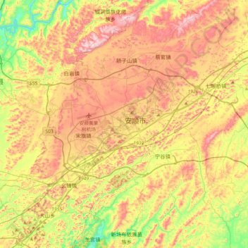
Naam: Topografische kaart Anshun, hoogte, reliëf.
Locatie: Anshun, Xixiu District, Anshun City, Guizhou, 561000, China (26.08970 105.76778 26.40970 106.08778)
Gemiddelde hoogte: 1.374 m
Minimale hoogte: 1.105 m
Maximale hoogte: 1.655 m