
Topografische kaart Cacouna
Interactieve kaart
Klik op de kaart om de hoogte weer te geven.
Over deze kaart
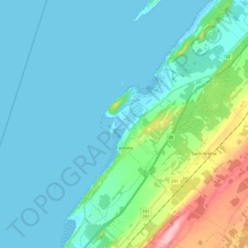
Naam: Topografische kaart Cacouna, hoogte, reliëf.
Gemiddelde hoogte: 27 m
Minimale hoogte: -1 m
Maximale hoogte: 156 m
Andere topografische kaarten
Klik op een kaart om zijn topografie, zijn hoogte en zijn reliëf te bekijken.
Saint-Hubert-de-Rivière-du-Loup
Canada > Québec > Rivière-du-Loup (MRC)
Saint-Hubert-de-Rivière-du-Loup, Rivière-du-Loup (MRC), Bas-Saint-Laurent, Québec, G0L 3L0, Canada
Gemiddelde hoogte: 341 m
Saint-Antonin
Canada > Québec > Rivière-du-Loup (MRC) > Saint-Antonin
Saint-Antonin, Rivière-du-Loup (MRC), Bas-Saint-Laurent, Québec, G0L 2J0, Canada
Gemiddelde hoogte: 224 m
Notre-Dame du-Portage
Canada > Québec > Rivière-du-Loup (MRC)
Notre-Dame du-Portage, Rivière-du-Loup (MRC), Bas-Saint-Laurent, Québec, Canada
Gemiddelde hoogte: 59 m
Saint-Modeste
Canada > Québec > Rivière-du-Loup (MRC) > Saint-Modeste
Saint-Modeste, Rivière-du-Loup (MRC), Bas-Saint-Laurent, Québec, Canada
Gemiddelde hoogte: 173 m
Rivière-du-Loup
Canada > Québec > Rivière-du-Loup (MRC)
Rivière-du-Loup, Rivière-du-Loup (MRC), Bas-Saint-Laurent, Québec, Canada
Gemiddelde hoogte: 64 m
Saint-Paul-de-la-Croix
Canada > Québec > Rivière-du-Loup (MRC)
Saint-Paul-de-la-Croix, Rivière-du-Loup (MRC), Bas-Saint-Laurent, Québec, G0L 1L0, Canada
Gemiddelde hoogte: 213 m
Fleuve Saint-Laurent, Estuaire moyen
Canada > Québec > Rivière-du-Loup (MRC)
Fleuve Saint-Laurent, Estuaire moyen, Rivière-du-Loup (MRC), Bas-Saint-Laurent, Québec, Canada
Gemiddelde hoogte: 317 m
L'Isle-Verte
Canada > Québec > Rivière-du-Loup (MRC)
L'Isle-Verte, Rivière-du-Loup (MRC), Bas-Saint-Laurent, Québec, G0L 1K0, Canada
Gemiddelde hoogte: 53 m
Saint-Arsène
Canada > Québec > Rivière-du-Loup (MRC)
Saint-Arsène, Rivière-du-Loup (MRC), Bas-Saint-Laurent, Québec, G5R 1L7, Canada
Gemiddelde hoogte: 70 m