
Topografische kaart Jerome
Interactieve kaart
Klik op de kaart om de hoogte weer te geven.
Over deze kaart
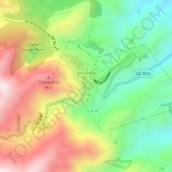
Naam: Topografische kaart Jerome, hoogte, reliëf.
Locatie: Jerome, Yavapai County, Arizona, 86331, United States (34.73958 -112.11939 34.75395 -112.09424)
Gemiddelde hoogte: 1.574 m
Minimale hoogte: 1.291 m
Maximale hoogte: 1.930 m
Jerome is about 100 miles (160 km) north of Phoenix and 45 miles (72 km) southwest of Flagstaff along Arizona State Route 89A between Sedona to the east and Prescott to the west. The town is in Arizona's Black Hills, which trend north–south. The town lies within the Prescott National Forest at an elevation of more than 5,000 feet (1,500 m). Woodchute Wilderness is about 3 miles (5 km) west of Jerome, and Mingus Mountain, at 7,726 feet (2,355 m) above sea level, is about 4 miles (6 km) south of town. Jerome State Historic Park is in the town itself. Bitter Creek, a tributary of the Verde River, flows intermittently through Jerome. East of Jerome at the base of the hills are the Verde Valley and the communities of Clarkdale and Cottonwood, site of the nearest airport.
Andere topografische kaarten
Klik op een kaart om zijn topografie, zijn hoogte en zijn reliëf te bekijken.
Glen Oaks
United States > Arizona > Yavapai County
Glen Oaks, Yavapai County, Arizona, United States
Gemiddelde hoogte: 1.717 m
Camp Verde
United States > Arizona > Yavapai County
Camp Verde, Yavapai County, Arizona, 86322, United States
Gemiddelde hoogte: 1.095 m
Cordes
United States > Arizona > Yavapai County
Cordes, Yavapai County, Arizona, 86333, United States
Gemiddelde hoogte: 1.170 m
Ocotillo
United States > Arizona > Yavapai County
Ocotillo, Yavapai County, Arizona, United States
Gemiddelde hoogte: 1.302 m
Paulden
United States > Arizona > Yavapai County
Paulden, Yavapai County, Arizona, United States
Gemiddelde hoogte: 1.408 m
Wagoner
United States > Arizona > Yavapai County > Wagoner
Wagoner, Yavapai County, Arizona, United States
Gemiddelde hoogte: 1.063 m
Prescott Valley
United States > Arizona > Yavapai County
Prescott Valley, Yavapai County, Arizona, United States
Gemiddelde hoogte: 1.550 m
Ash Fork
United States > Arizona > Yavapai County > Ash Fork
Ash Fork, Yavapai County, Arizona, 86320, United States
Gemiddelde hoogte: 1.561 m
Dewey
United States > Arizona > Yavapai County > Prescott Valley > Dewey
Dewey, Prescott Valley, Yavapai County, Arizona, 86329, United States
Gemiddelde hoogte: 1.415 m
Sedona
United States > Arizona > Yavapai County
Sedona, Yavapai County, Arizona, 86336, United States
Gemiddelde hoogte: 1.342 m
Cleator
United States > Arizona > Yavapai County
Cleator, Yavapai County, Arizona, United States
Gemiddelde hoogte: 1.083 m
Pica
United States > Arizona > Yavapai County
Pica, Yavapai County, Arizona, United States
Gemiddelde hoogte: 1.613 m
Prescott
United States > Arizona > Yavapai County
Prescott, Yavapai County, Arizona, United States
Gemiddelde hoogte: 1.674 m
Audley
United States > Arizona > Yavapai County
Audley, Yavapai County, Arizona, 96337, United States
Gemiddelde hoogte: 1.591 m