
Topografische kaart Floyds Knobs
Interactieve kaart
Klik op de kaart om de hoogte weer te geven.
Over deze kaart
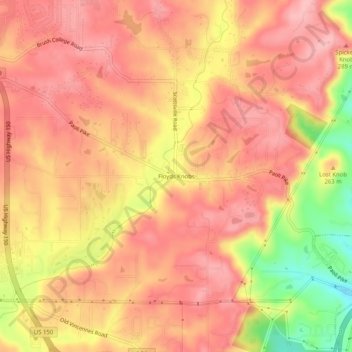
Naam: Topografische kaart Floyds Knobs, hoogte, reliëf.
Locatie: Floyds Knobs, Floyd County, Indiana, 47146, United States (38.30438 -85.89353 38.34438 -85.85353)
Gemiddelde hoogte: 251 m
Minimale hoogte: 157 m
Maximale hoogte: 293 m
Andere topografische kaarten
Klik op een kaart om zijn topografie, zijn hoogte en zijn reliëf te bekijken.
Greenville
United States > Indiana > Floyd County
Greenville, Floyd County, Indiana, 47124, United States
Gemiddelde hoogte: 245 m
Georgetown
United States > Indiana > Floyd County
Georgetown, Floyd County, Indiana, 47122, United States
Gemiddelde hoogte: 248 m
Galena
United States > Indiana > Floyd County
Galena, Floyd County, Indiana, United States
Gemiddelde hoogte: 232 m
New Albany
United States > Indiana > Floyd County
New Albany, Floyd County, Indiana, 47150, United States
Gemiddelde hoogte: 180 m
Silver Hills
United States > Indiana > Floyd County > New Albany
Silver Hills, New Albany, Floyd County, Indiana, 47150, United States
Gemiddelde hoogte: 160 m
Edwardsville
United States > Indiana > Floyd County
Edwardsville, Floyd County, Indiana, United States
Gemiddelde hoogte: 249 m