
Topografische kaart Coachella Valley
Interactieve kaart
Klik op de kaart om de hoogte weer te geven.
Coachella Valley
The area is surrounded on the southwest by the Santa Rosa Mountains, by the San Jacinto Mountains to the west, the Little San Bernardino Mountains to the east and San Gorgonio Mountain to the north. These mountains peak at around 11,000 feet (3,400 m) and tend to average between 5,000 and 7,000 feet (1,500 and 2,100 m). Elevations on the Valley floor range from 1,600 feet (490 m) above sea level at the north end of the Valley to 250 feet (76 m) below sea level around Mecca.
Over deze kaart
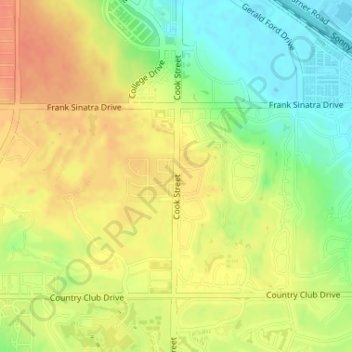
Naam: Topografische kaart Coachella Valley, hoogte, reliëf.
Gemiddelde hoogte: 72 m
Minimale hoogte: 47 m
Maximale hoogte: 91 m
Andere topografische kaarten
Klik op een kaart om zijn topografie, zijn hoogte en zijn reliëf te bekijken.
Palm Desert
United States > California > Riverside County > Palm Desert
The elevation (at City Hall) is 224 feet (68 m) above sea level. Elevations vary from the lower northern half once covered in sand dunes to the upper slope southern cove (300–900 feet or 91–274 metres) all the way to the ridgeline at 1,000 feet (300 m). Palm Desert is in the Coachella Valley, the…
Gemiddelde hoogte: 298 m