
Topografische kaart Dwight
Interactieve kaart
Klik op de kaart om de hoogte weer te geven.
Over deze kaart
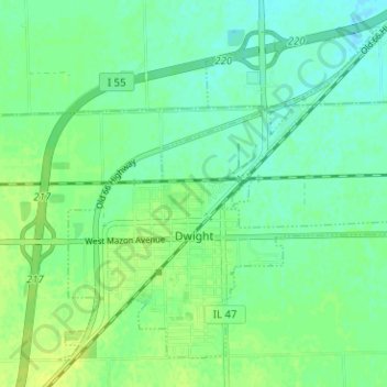
Naam: Topografische kaart Dwight, hoogte, reliëf.
Locatie: Dwight, Livingston County, Illinois, United States (41.07914 -88.44730 41.12024 -88.38422)
Gemiddelde hoogte: 194 m
Minimale hoogte: 187 m
Maximale hoogte: 201 m
Andere topografische kaarten
Klik op een kaart om zijn topografie, zijn hoogte en zijn reliëf te bekijken.
Pontiac
United States > Illinois > Livingston County
Pontiac, Pontiac Township, Livingston County, Illinois, 61764, United States
Gemiddelde hoogte: 199 m
Long Point
United States > Illinois > Livingston County
Long Point, Livingston County, Illinois, United States
Gemiddelde hoogte: 195 m
Odell
United States > Illinois > Livingston County
Odell, Livingston County, Illinois, 60460, United States
Gemiddelde hoogte: 218 m
Cornell
United States > Illinois > Livingston County > Cornell
Cornell, Amity Township, Livingston County, Illinois, 61319, United States
Gemiddelde hoogte: 192 m
Cornell
United States > Illinois > Livingston County
Cornell, Amity Township, Livingston County, Illinois, United States
Gemiddelde hoogte: 193 m
Forrest
United States > Illinois > Livingston County
Forrest, Livingston County, Illinois, 61741, United States
Gemiddelde hoogte: 212 m