
Topografische kaart Distrito Ciudad de Luján de Cuyo
Interactieve kaart
Klik op de kaart om de hoogte weer te geven.
Distrito Ciudad de Luján de Cuyo
Situated in the upper Mendoza valley, where the river is half-way through its journey from the Andes mountains to the eastern plains, many Lujan de Cuyo vineyards sit at altitudes of around 1000 m (3280 ft). Malbec in particular is successful in Lujan de Cuyo, but the appellation also produces good Cabernet Sauvignon, Chardonnay and Torrontes. The majority of the vineyards are on alluvial soils; sandy or stony surfaces on clay substrata.
Over deze kaart
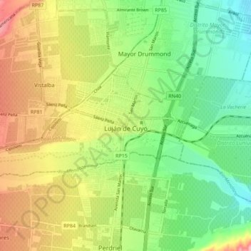
Naam: Topografische kaart Distrito Ciudad de Luján de Cuyo, hoogte, reliëf.
Gemiddelde hoogte: 949 m
Minimale hoogte: 888 m
Maximale hoogte: 1.033 m
Andere topografische kaarten
Klik op een kaart om zijn topografie, zijn hoogte en zijn reliëf te bekijken.
Luján de Cuyo
Argentina > Mendoza > Departamento Luján de Cuyo > Luján de Cuyo
Gemiddelde hoogte: 943 m