
Topografische kaart Puttenham
Klik op de kaart om de hoogte weer te geven.
Over deze kaart
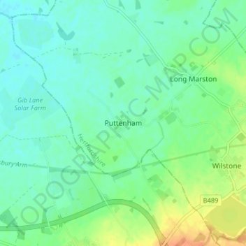
Naam: Topografische kaart Puttenham, hoogte, reliëf.
Gemiddelde hoogte: 89 m
Minimale hoogte: 78 m
Maximale hoogte: 111 m
Andere topografische kaarten
Klik op een kaart om zijn topografie, zijn hoogte en zijn reliëf te bekijken.
Berkhamsted
United Kingdom > England > Hertfordshire > Dacorum > Northchurch
The layout of Berkhamsted's centre is typical of a medieval market settlement: the linear High Street (aligned on the Akeman Street) forms the spine of the town (roughly aligned east–west), from which extend medieval burgage plots (to the north and south). The surviving burgage plot layout is the result of a…
Gemiddelde hoogte: 142 m
Saint Margarets Copse
United Kingdom > England > Hertfordshire > Dacorum > Great Gaddesden
Gemiddelde hoogte: 144 m
Tringford Reservoir
United Kingdom > England > Hertfordshire > Dacorum > Tring > Wilstone
Gemiddelde hoogte: 119 m
Great Gaddesden
United Kingdom > England > Hertfordshire > Dacorum > Gaddesden Row
Gemiddelde hoogte: 146 m
Westbrook Mere
United Kingdom > England > Hertfordshire > Dacorum > Bourne End
Gemiddelde hoogte: 125 m
Phasels Wood
United Kingdom > England > Hertfordshire > Dacorum > Kings Langley > Felden
Gemiddelde hoogte: 128 m
Frithsden Beeches
United Kingdom > England > Hertfordshire > Dacorum > Potten End
Gemiddelde hoogte: 160 m
Little Gaddesden
United Kingdom > England > Hertfordshire > Dacorum > Little Gaddesden
Gemiddelde hoogte: 175 m
Berkhamsted
United Kingdom > England > Hertfordshire > Dacorum
The layout of Berkhamsted's centre is typical of a medieval market settlement: the linear High Street (aligned on the Akeman Street) forms the spine of the town (roughly aligned east–west), from which extend medieval burgage plots (to the north and south). The surviving burgage plot layout is the result of a…
Gemiddelde hoogte: 145 m