
Topografische kaart Rathfeigh
Interactieve kaart
Klik op de kaart om de hoogte weer te geven.
Over deze kaart
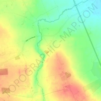
Naam: Topografische kaart Rathfeigh, hoogte, reliëf.
Gemiddelde hoogte: 65 m
Minimale hoogte: 34 m
Maximale hoogte: 92 m
Andere topografische kaarten
Klik op een kaart om zijn topografie, zijn hoogte en zijn reliëf te bekijken.
Slane
Slane, The Municipal District of Laytown — Bettystown, County Meath, Leinster, Ireland
Gemiddelde hoogte: 66 m
Castletown
Castletown, The Municipal District of Kells, County Meath, Leinster, Ireland
Gemiddelde hoogte: 72 m
Navan
Navan, The Municipal District of Navan, County Meath, Leinster, Ireland
Gemiddelde hoogte: 52 m
Longwood
Longwood, Castlerickard ED, The Municipal District of Trim, County Meath, Leinster, Ireland
Gemiddelde hoogte: 69 m
Proudstown
Proudstown, Navan Rural ED, The Municipal District of Navan, County Meath, Leinster, C15 A623, Ireland
Gemiddelde hoogte: 66 m
Dunboyne
Dunboyne, Dunboyne ED, The Municipal District of Ratoath, County Meath, Leinster, Ireland
Gemiddelde hoogte: 72 m
Ballymahon
Ballymahon, Castlerickard ED, The Municipal District of Trim, County Meath, Leinster, Ireland
Gemiddelde hoogte: 66 m
Hill of Tara
Hill of Tara, The Municipal District of Ashbourne, County Meath, Leinster, C15 NYY6, Ireland
Gemiddelde hoogte: 106 m
The Municipal District of Navan
The Municipal District of Navan, County Meath, Leinster, Ireland
Gemiddelde hoogte: 62 m
The Municipal District of Laytown — Bettystown
The Municipal District of Laytown — Bettystown, County Meath, Leinster, Ireland
Gemiddelde hoogte: 72 m
Stonestown
Stonestown, Kilbride ED, The Municipal District of Trim, County Meath, Leinster, Ireland
Gemiddelde hoogte: 69 m
Slane
Slane, Slane ED, The Municipal District of Laytown — Bettystown, County Meath, Leinster, Ireland
Gemiddelde hoogte: 69 m
Clonymeath
Clonymeath, Summerhill ED, The Municipal District of Trim, County Meath, Leinster, Ireland
Gemiddelde hoogte: 85 m
The Municipal District of Kells
The Municipal District of Kells, County Meath, Leinster, Ireland
Gemiddelde hoogte: 96 m
Lobinstown
Lobinstown, Killary ED, The Municipal District of Laytown — Bettystown, County Meath, Leinster, Ireland
Gemiddelde hoogte: 70 m
Gaskinstown
Gaskinstown, Duleek ED, The Municipal District of Laytown — Bettystown, County Meath, Leinster, Ireland
Gemiddelde hoogte: 44 m
Dunshaughlin
Ireland > County Meath > Dunshaughlin
Dunshaughlin, The Municipal District of Ratoath, County Meath, Leinster, A85 C840, Ireland
Gemiddelde hoogte: 99 m
Dunboyne
Ireland > County Meath > Dunboyne
Dunboyne, The Municipal District of Ratoath, County Meath, Leinster, A86 R688, Ireland
Gemiddelde hoogte: 73 m
Kells
Ireland > County Meath > Kells
Kells, The Municipal District of Kells, County Meath, Leinster, A82 KD62, Ireland
Gemiddelde hoogte: 70 m
Bettystown
Bettystown, The Municipal District of Laytown — Bettystown, County Meath, Leinster, A92 AH27, Ireland
Gemiddelde hoogte: 6 m
The Municipal District of Ashbourne
The Municipal District of Ashbourne, County Meath, Leinster, Ireland
Gemiddelde hoogte: 75 m
The Municipal District of Ratoath
The Municipal District of Ratoath, County Meath, Leinster, Ireland
Gemiddelde hoogte: 87 m
Navan
Ireland > County Meath > Navan
Navan, The Municipal District of Navan, County Meath, Leinster, C15H6EK, Ireland
Gemiddelde hoogte: 59 m
Ashbourne
Ireland > County Meath > Ashbourne
Ashbourne, The Municipal District of Ashbourne, County Meath, Leinster, A84 WK40, Ireland
Gemiddelde hoogte: 78 m