
Topografische kaart Podgórze
Interactieve kaart
Klik op de kaart om de hoogte weer te geven.
Over deze kaart
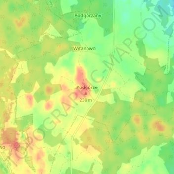
Naam: Topografische kaart Podgórze, hoogte, reliëf.
Gemiddelde hoogte: 204 m
Minimale hoogte: 174 m
Maximale hoogte: 235 m
Andere topografische kaarten
Klik op een kaart om zijn topografie, zijn hoogte en zijn reliëf te bekijken.
Półczno
Poland > Pomeranian Voivodeship > Bytów County
Półczno, gmina Studzienice, Bytów County, Pomeranian Voivodeship, 77-125, Poland
Gemiddelde hoogte: 193 m
Będzieszyn
Poland > Pomeranian Voivodeship > Bytów County > Jasień
Będzieszyn, Jasień, gmina Czarna Dąbrówka, Bytów County, Pomeranian Voivodeship, Poland
Gemiddelde hoogte: 154 m
Pomysk Wielki
Poland > Pomeranian Voivodeship > Bytów County > Pomysk Wielki
Pomysk Wielki, gmina Bytów, Bytów County, Pomeranian Voivodeship, 77-100, Poland
Gemiddelde hoogte: 170 m