
Topografische kaart Cedar Bench Wilderness
Interactieve kaart
Klik op de kaart om de hoogte weer te geven.
Over deze kaart
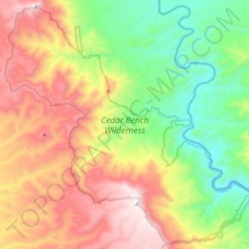
Naam: Topografische kaart Cedar Bench Wilderness, hoogte, reliëf.
Gemiddelde hoogte: 1.349 m
Minimale hoogte: 822 m
Maximale hoogte: 2.029 m
Cedar Bench Wilderness is a protected wilderness area in the Prescott National Forest in the U.S. state of Arizona. Established in 1984 under the Arizona Wilderness Act, the area protects the large "bench" that divides the Agua Fria and Verde River drainages. Elevations range from 4,500 feet (1,371 m) to 6,700 feet (2,042 m) with vegetation that includes saguaro cactus along the Verde river to chaparral to smaller amounts of pinyon pine and Utah juniper along the high points.
Andere topografische kaarten
Klik op een kaart om zijn topografie, zijn hoogte en zijn reliëf te bekijken.
Camp Verde
United States > Arizona > Yavapai County
Camp Verde, Yavapai County, Arizona, 86322, United States
Gemiddelde hoogte: 1.095 m
Skull Valley
United States > Arizona > Yavapai County
Skull Valley, Yavapai County, Arizona, 86338, United States
Gemiddelde hoogte: 1.342 m
Sedona
United States > Arizona > Yavapai County
Sedona, Yavapai County, Arizona, 86336, United States
Gemiddelde hoogte: 1.342 m
Peeples Valley
United States > Arizona > Yavapai County
Peeples Valley, Yavapai County, Arizona, 86332, United States
Gemiddelde hoogte: 1.472 m
Lake Montezuma
United States > Arizona > Yavapai County > Rimrock
Lake Montezuma, Rimrock, Yavapai County, Arizona, United States
Gemiddelde hoogte: 1.075 m
Yarnell
United States > Arizona > Yavapai County
Yarnell, Yavapai County, Arizona, 85362, United States
Gemiddelde hoogte: 1.472 m
Verde Village
United States > Arizona > Yavapai County
Verde Village, Yavapai County, Arizona, United States
Gemiddelde hoogte: 1.040 m
Prescott
United States > Arizona > Yavapai County
Prescott, Yavapai County, Arizona, United States
Gemiddelde hoogte: 1.674 m
Seligman
United States > Arizona > Yavapai County > Seligman
Seligman, Yavapai County, Arizona, 86337, United States
Gemiddelde hoogte: 1.617 m
Perkinsville
United States > Arizona > Yavapai County
Perkinsville, Yavapai County, Arizona, United States
Gemiddelde hoogte: 1.256 m
Chimney Rock
United States > Arizona > Yavapai County
Chimney Rock, Yavapai County, Arizona, 86336, United States
Gemiddelde hoogte: 1.441 m
Black Canyon City
United States > Arizona > Yavapai County
Black Canyon City, Yavapai County, Arizona, 85324, United States
Gemiddelde hoogte: 700 m
Kirkland
United States > Arizona > Yavapai County
Kirkland, Yavapai County, Arizona, United States
Gemiddelde hoogte: 1.228 m
Williamson Valley Wash
United States > Arizona > Yavapai County
Williamson Valley Wash, Yavapai County, Arizona, United States
Gemiddelde hoogte: 1.337 m
Paradise Acres
United States > Arizona > Yavapai County > Camp Verde
Paradise Acres, Camp Verde, Yavapai County, Arizona, United States
Gemiddelde hoogte: 948 m
Mount Union Family Picnic Ground
United States > Arizona > Yavapai County
Mount Union Family Picnic Ground, Yavapai County, Arizona, United States
Gemiddelde hoogte: 2.232 m
Arcosanti
United States > Arizona > Yavapai County
Arcosanti, Yavapai County, Arizona, United States
Gemiddelde hoogte: 1.130 m
Clarkdale
United States > Arizona > Yavapai County
Clarkdale, Yavapai County, Arizona, 86324, United States
Gemiddelde hoogte: 1.211 m
Dewey-Humboldt
United States > Arizona > Yavapai County
Dewey-Humboldt, Yavapai County, Arizona, 86329, United States
Gemiddelde hoogte: 1.464 m
Lake Pleasant
United States > Arizona > Yavapai County > Peoria
Lake Pleasant, Peoria, Yavapai County, Arizona, United States
Gemiddelde hoogte: 565 m
Rimrock
United States > Arizona > Yavapai County
Rimrock, Yavapai County, Arizona, 86342, United States
Gemiddelde hoogte: 1.092 m
Mesa Verde Estates
United States > Arizona > Yavapai County > Camp Verde
Mesa Verde Estates, Camp Verde, Yavapai County, Arizona, 86322, United States
Gemiddelde hoogte: 969 m
Jacks Canyon
United States > Arizona > Yavapai County
Jacks Canyon, Yavapai County, Arizona, United States
Gemiddelde hoogte: 1.507 m
Ocotillo
United States > Arizona > Yavapai County
Ocotillo, Yavapai County, Arizona, United States
Gemiddelde hoogte: 1.302 m
Paulden
United States > Arizona > Yavapai County
Paulden, Yavapai County, Arizona, United States
Gemiddelde hoogte: 1.408 m
Blue Rock Dam
United States > Arizona > Yavapai County
Blue Rock Dam, Yavapai County, Arizona, United States
Gemiddelde hoogte: 1.563 m
Clear Creek
United States > Arizona > Yavapai County > Camp Verde
Clear Creek, Camp Verde, Yavapai County, Arizona, United States
Gemiddelde hoogte: 954 m
Miller Valley
United States > Arizona > Yavapai County > Prescott
Miller Valley, Prescott, Yavapai County, Arizona, 86305, United States
Gemiddelde hoogte: 1.663 m
Prescott Valley
United States > Arizona > Yavapai County
Prescott Valley, Yavapai County, Arizona, United States
Gemiddelde hoogte: 1.550 m
Granite Mountain Wilderness
United States > Arizona > Yavapai County
Granite Mountain Wilderness, Yavapai County, Arizona, United States
Gemiddelde hoogte: 1.718 m
Mayer
United States > Arizona > Yavapai County
Mayer, Yavapai County, Arizona, United States
Gemiddelde hoogte: 1.427 m
Seligman
United States > Arizona > Yavapai County
Seligman, Yavapai County, Arizona, 86337, United States
Gemiddelde hoogte: 1.617 m
Ruin Point Tank
United States > Arizona > Yavapai County
Ruin Point Tank, Yavapai County, Arizona, United States
Gemiddelde hoogte: 939 m
Chino Valley
United States > Arizona > Yavapai County
Chino Valley, Yavapai County, Arizona, 86323, United States
Gemiddelde hoogte: 1.454 m
Granite Mountain
United States > Arizona > Yavapai County
Granite Mountain, Yavapai County, Arizona, United States
Gemiddelde hoogte: 1.915 m
Cordes Lakes
United States > Arizona > Yavapai County
Cordes Lakes, Yavapai County, Arizona, United States
Gemiddelde hoogte: 1.141 m
Willow Spring
United States > Arizona > Yavapai County
Willow Spring, Yavapai County, Arizona, United States
Gemiddelde hoogte: 1.447 m
Jerome
United States > Arizona > Yavapai County
Jerome, Yavapai County, Arizona, 86331, United States
Gemiddelde hoogte: 1.574 m
Yava
United States > Arizona > Yavapai County
Yava, Yavapai County, Arizona, United States
Gemiddelde hoogte: 1.095 m
Crown King
United States > Arizona > Yavapai County
Crown King, Yavapai County, Arizona, 86343, United States
Gemiddelde hoogte: 1.902 m
Agua Fria National Monument
United States > Arizona > Yavapai County
Agua Fria National Monument, Yavapai County, Arizona, United States
Gemiddelde hoogte: 1.161 m
House Mountain
United States > Arizona > Yavapai County
House Mountain, Yavapai County, Arizona, United States
Gemiddelde hoogte: 1.417 m
Briggs
United States > Arizona > Yavapai County
Briggs, Yavapai County, Arizona, United States
Gemiddelde hoogte: 940 m
Woodchute Mountain
United States > Arizona > Yavapai County
Woodchute Mountain, Yavapai County, Arizona, United States
Gemiddelde hoogte: 2.167 m
Ash Fork
United States > Arizona > Yavapai County
Ash Fork, Yavapai County, Arizona, 86320, United States
Gemiddelde hoogte: 1.561 m
Cottonwood
United States > Arizona > Yavapai County
Cottonwood, Yavapai County, Arizona, 86236, United States
Gemiddelde hoogte: 1.118 m
Cornville
United States > Arizona > Yavapai County
Cornville, Yavapai County, Arizona, United States
Gemiddelde hoogte: 1.129 m