
Topografische kaart Cottonwood Shores
Interactieve kaart
Klik op de kaart om de hoogte weer te geven.
Over deze kaart
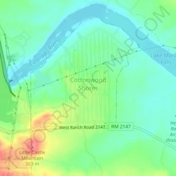
Naam: Topografische kaart Cottonwood Shores, hoogte, reliëf.
Locatie: Cottonwood Shores, Burnet County, Texas, United States (30.54425 -98.34183 30.56596 -98.31472)
Gemiddelde hoogte: 247 m
Minimale hoogte: 223 m
Maximale hoogte: 297 m
Andere topografische kaarten
Klik op een kaart om zijn topografie, zijn hoogte en zijn reliëf te bekijken.
Marble Falls
United States > Texas > Burnet County
Marble Falls, Burnet County, Texas, 76654, United States
Gemiddelde hoogte: 278 m
Bertram
United States > Texas > Burnet County > Bertram
Bertram, Burnet County, Texas, 78605, United States
Gemiddelde hoogte: 372 m
Silver Creek Village
United States > Texas > Burnet County > Silver Creek Village
Silver Creek Village, Burnet County, Texas, United States
Gemiddelde hoogte: 347 m
Granite Shoals
United States > Texas > Burnet County > Granite Shoals
Granite Shoals, Burnet County, Texas, United States
Gemiddelde hoogte: 263 m
Marble Falls
United States > Texas > Burnet County > Marble Falls > Marble Falls
Marble Falls, Burnet County, Texas, 76654, United States
Gemiddelde hoogte: 261 m
Spicewood
United States > Texas > Burnet County
Spicewood, Burnet County, Texas, United States
Gemiddelde hoogte: 251 m