
Topografische kaart Delta
Interactieve kaart
Klik op de kaart om de hoogte weer te geven.
Over deze kaart
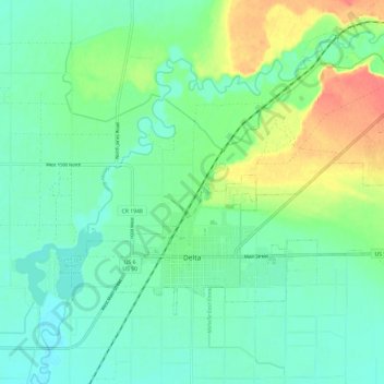
Naam: Topografische kaart Delta, hoogte, reliëf.
Locatie: Delta, Millard County, Utah, United States (39.33856 -112.61453 39.39694 -112.49604)
Gemiddelde hoogte: 1.417 m
Minimale hoogte: 1.401 m
Maximale hoogte: 1.453 m
Delta experiences a cold semi-arid climate (Köppen BSk) with hot summers and cold winters. Because of Delta's altitude and aridity, temperatures drop quickly after sunset, especially in the summer. Winters are cold. Daytime highs in the winter are usually above freezing, but nighttime lows drop well below freezing, occasionally falling below 0 °F or −17.8 °C. Delta's climate is similar to that of Salt Lake City, but much more arid.
Andere topografische kaarten
Klik op een kaart om zijn topografie, zijn hoogte en zijn reliëf te bekijken.
Lynndyl
United States > Utah > Millard County
Lynndyl, Millard County, Utah, 84640, United States
Gemiddelde hoogte: 1.451 m
Fillmore
United States > Utah > Millard County
Fillmore, Millard County, Utah, 84631, United States
Gemiddelde hoogte: 1.584 m
West Desert Sinkhole
United States > Utah > Millard County
West Desert Sinkhole, Millard County, Utah, United States
Gemiddelde hoogte: 1.707 m