
Topografische kaart Marlow
Interactieve kaart
Klik op de kaart om de hoogte weer te geven.
Marlow
According to the United States Census Bureau, the town has a total area of 26.4 square miles (68 km2), of which 26.0 sq mi (67 km2) is land and 0.5 sq mi (1.3 km2) is water, comprising 1.78% of the town. Marlow is drained by the Ashuelot River. The town's highest point is in its northeast corner, at the summit of Huntley Mountain, where the elevation reaches 1,978 feet (603 m) above sea level.
Over deze kaart
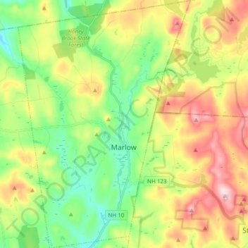
Naam: Topografische kaart Marlow, hoogte, reliëf.
Gemiddelde hoogte: 446 m
Minimale hoogte: 311 m
Maximale hoogte: 648 m