
Topografische kaart Ettalong Beach
Interactieve kaart
Klik op de kaart om de hoogte weer te geven.
Over deze kaart
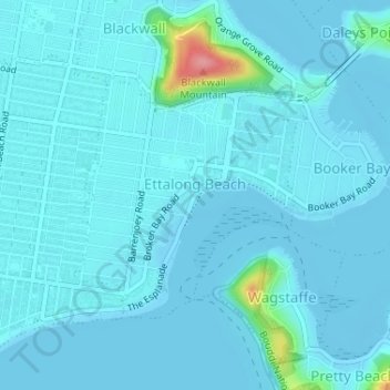
Naam: Topografische kaart Ettalong Beach, hoogte, reliëf.
Gemiddelde hoogte: 9 m
Minimale hoogte: -4 m
Maximale hoogte: 103 m
Andere topografische kaarten
Klik op een kaart om zijn topografie, zijn hoogte en zijn reliëf te bekijken.
Somersby
Australia > New South Wales > Gosford
Somersby, Gosford, Central Coast Council, New South Wales, 2250, Australia
Gemiddelde hoogte: 151 m
Kariong
Australia > New South Wales > Gosford
Kariong, Gosford, Central Coast Council, New South Wales, 2250, Australia
Gemiddelde hoogte: 86 m
Narara
Australia > New South Wales > Gosford
Narara, Gosford, Central Coast Council, New South Wales, 2250, Australia
Gemiddelde hoogte: 55 m
Robinson Creek
Australia > New South Wales > Gosford
Robinson Creek, Somersby, Gosford, Central Coast Council, New South Wales, 2250, Australia
Gemiddelde hoogte: 229 m
Umina Beach
Australia > New South Wales > Gosford
Umina Beach, Gosford, Central Coast Council, New South Wales, 2257, Australia
Gemiddelde hoogte: 38 m
Hawkesbury River
Australia > New South Wales > Gosford > Cowan
Hawkesbury River, Cowan, Gosford, Central Coast Council, New South Wales, 2083, Australia
Gemiddelde hoogte: 82 m