
Topografische kaart Andros Island
Interactieve kaart
Klik op de kaart om de hoogte weer te geven.
Over deze kaart
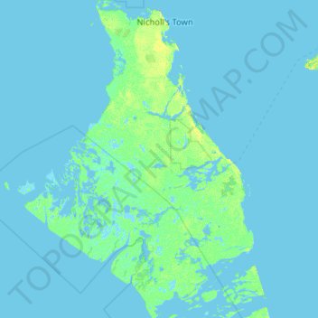
Naam: Topografische kaart Andros Island, hoogte, reliëf.
Locatie: Andros Island, The Bahamas (24.26893 -78.46197 25.20498 -77.71598)
Gemiddelde hoogte: 1 m
Minimale hoogte: -6 m
Maximale hoogte: 23 m
Andere topografische kaarten
Klik op een kaart om zijn topografie, zijn hoogte en zijn reliëf te bekijken.
Stanleyville
Stanleyville, New Providence, The Bahamas
Gemiddelde hoogte: 7 m
Harbour Island
Harbour Island, Dunmore Town, Harbour Island, The Bahamas
Gemiddelde hoogte: 1 m
Rose Island
Rose Island, Nassau, New Providence, The Bahamas
Gemiddelde hoogte: 0 m
Williams Island
Williams Island, North Andros, The Bahamas
Gemiddelde hoogte: 0 m
Highbury Park
Highbury Park, New Providence, The Bahamas
Gemiddelde hoogte: 7 m
Grand Bahama
The Bahamas > East Grand Bahama
Grand Bahama, East Grand Bahama, The Bahamas
Gemiddelde hoogte: 1 m
Russell Island
Russell Island, Spanish Wells, The Bahamas
Gemiddelde hoogte: 1 m
Bimini
The Bahamas > Bimini > Bailey Town
Bimini, Bailey Town, Bimini, The Bahamas
Gemiddelde hoogte: 1 m
Charlotteville
Charlotteville, New Providence, The Bahamas
Gemiddelde hoogte: 5 m
Little Whale Cay
The Bahamas > West Grand Bahama
Little Whale Cay, West Grand Bahama, The Bahamas
Gemiddelde hoogte: 0 m