
Topografische kaart Danbury
Interactieve kaart
Klik op de kaart om de hoogte weer te geven.
Danbury
The highest point in Danbury is the summit of Tinkham Hill, at 2,320 feet (710 m) above sea level, in the northern part of town. Ragged Mountain is a prominent mountain with multiple summits which occupies the southern portion of town and has a ski area of the same name; the elevation of the Danbury summit of Ragged is 2,225 ft (678 m) above sea level. The Sunapee-Ragged-Kearsarge Greenway hiking trail crosses a corner of Danbury along Ragged Mountain's Ridge Trail. Access to the Ridge Trail from the SRK Greenway is on the SRKG 6.1 mile trail section 9, either from trailhead parking on New Canada Road in Wilmot from the northwest or from Proctor Academy's trailhead parking in Andover from the southeast.
Over deze kaart
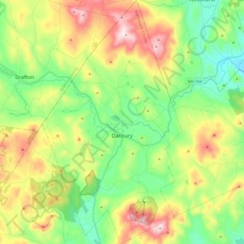
Naam: Topografische kaart Danbury, hoogte, reliëf.
Gemiddelde hoogte: 349 m
Minimale hoogte: 138 m
Maximale hoogte: 700 m
Andere topografische kaarten
Klik op een kaart om zijn topografie, zijn hoogte en zijn reliëf te bekijken.
Rings Corner
United States > New Hampshire > Merrimack County > Pittsfield > Rings Corner
Gemiddelde hoogte: 190 m