
Topografische kaart 滘西洲 Kau Sai Chau
Interactieve kaart
Klik op de kaart om de hoogte weer te geven.
Over deze kaart
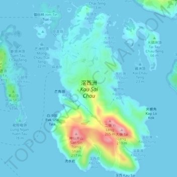
Naam: Topografische kaart 滘西洲 Kau Sai Chau, hoogte, reliëf.
Gemiddelde hoogte: 21 m
Minimale hoogte: -2 m
Maximale hoogte: 187 m
Andere topografische kaarten
Klik op een kaart om zijn topografie, zijn hoogte en zijn reliëf te bekijken.
蓮花山 Lin Fa Shan
Chine > Hong Kong > 離島區 Islands District
蓮花山 Lin Fa Shan, 離島區 Islands District, Nouveaux Territoires, Hong Kong, Chine
Gemiddelde hoogte: 403 m
孔嶺 Hung Leng
Chine > Hong Kong > 北區 North District > 軍地村 Kwan Tei Tsuen
孔嶺 Hung Leng, 軍地村 Kwan Tei Tsuen, 北區 North District, Nouveaux Territoires, Hong Kong, Chine
Gemiddelde hoogte: 55 m
中區 Central District
Chine > Hong Kong > Île de Hong Kong
中區 Central District, Île de Hong Kong, Hong Kong, Chine
Gemiddelde hoogte: 114 m
獺灣 Chat Wan
Chine > Hong Kong > 西貢區 Sai Kung District
獺灣 Chat Wan, 西貢區 Sai Kung District, Nouveaux Territoires, Hong Kong, Chine
Gemiddelde hoogte: 17 m
鳳園 Fung Yuen
Chine > Hong Kong > 大埔區 Tai Po District > 鳳園 Fung Yuen
鳳園 Fung Yuen, 大埔區 Tai Po District, Nouveaux Territoires, Hong Kong, Chine
Gemiddelde hoogte: 80 m
北區 North District
北區 North District, Nouveaux Territoires, Hong Kong, Chine
Gemiddelde hoogte: 115 m
九肚 Kau To
Chine > Hong Kong > 九肚 Kau To > 沙田 Sha Tin
九肚 Kau To, 沙田 Sha Tin, 沙田區 Sha Tin District, Nouveaux Territoires, Hong Kong, Chine
Gemiddelde hoogte: 110 m