
Topografische kaart Kota
Interactieve kaart
Klik op de kaart om de hoogte weer te geven.
Over deze kaart
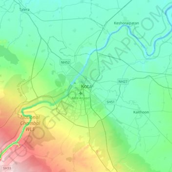
Naam: Topografische kaart Kota, hoogte, reliëf.
Locatie: Kota, Ladpura Tehsil, Kota District, Rajasthan, 324001, India (25.01370 75.69742 25.33370 76.01742)
Gemiddelde hoogte: 286 m
Minimale hoogte: 228 m
Maximale hoogte: 483 m
Andere topografische kaarten
Klik op een kaart om zijn topografie, zijn hoogte en zijn reliëf te bekijken.
Hanotiya
India > Rajasthan > Ladpura Tehsil > Hanotiya
Hanotiya, Ladpura Tehsil, Kota District, Rajasthan, 325003, India
Gemiddelde hoogte: 366 m