
Topografische kaart Temple Hill
Interactieve kaart
Klik op de kaart om de hoogte weer te geven.
Over deze kaart
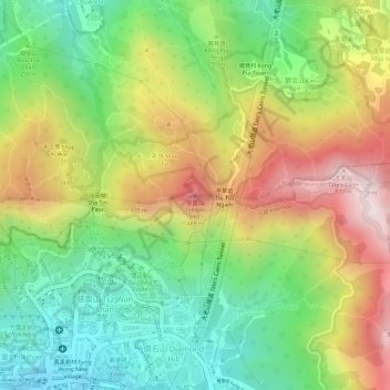
Naam: Topografische kaart Temple Hill, hoogte, reliëf.
Gemiddelde hoogte: 262 m
Minimale hoogte: 19 m
Maximale hoogte: 552 m
Andere topografische kaarten
Klik op een kaart om zijn topografie, zijn hoogte en zijn reliëf te bekijken.
Wo Liu Hang Village
China > Hong Kong > Sha Tin District > Wo Liu Hang Village
Wo Liu Hang Village, Sha Tin District, New Territories, Hong Kong, China
Gemiddelde hoogte: 111 m
Wu Kai Sha Village
China > Hong Kong > Sha Tin District > Wu Kai Sha Village
Wu Kai Sha Village, Sha Tin District, New Territories, Hong Kong, China
Gemiddelde hoogte: 72 m
Nui Po Au
China > Hong Kong > Sha Tin District > Mui Tsz Lam
Nui Po Au, Mui Tsz Lam, Sha Tin District, New Territories, Hong Kong, China
Gemiddelde hoogte: 229 m