
Topografische kaart Ephrata
Interactieve kaart
Klik op de kaart om de hoogte weer te geven.
Over deze kaart
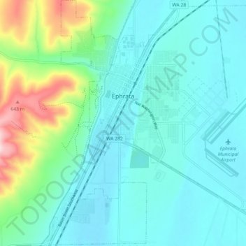
Naam: Topografische kaart Ephrata, hoogte, reliëf.
Locatie: Ephrata, Grant County, Washington, 98823, United States (47.28070 -119.58373 47.34123 -119.49620)
Gemiddelde hoogte: 434 m
Minimale hoogte: 373 m
Maximale hoogte: 685 m
The settlement of Ephrata is quite recent. There was no known settlement until 1886, just three years before Washington gained statehood. The horse rancher Frank Beezley was the first to settle near the natural springs, thus the area was known as Beezley Springs. As the climate and topography were not promising to settlement, the entire region remained sparsely populated until several federal congressional actions, including the Northern Pacific Land Grant Act, the Homestead Act, and Desert Claims Act, encouraged the settlement of this semi-arid desert-like area. Originally, Douglas County spread over the entire territory of the Big Bend of the Columbia River. In 1909, the Washington State legislature divided it, creating Grant County. When the time came to present arguments to the state legislature regarding which town should be the county seat, someone apparently intentionally intoxicated the representative of a rival community, and Ephrata was chosen.
Andere topografische kaarten
Klik op een kaart om zijn topografie, zijn hoogte en zijn reliëf te bekijken.
Moses Lake
United States > Washington > Grant County
Moses Lake, Grant County, Washington, 98837, United States
Gemiddelde hoogte: 350 m
Coulee City
United States > Washington > Grant County
Coulee City, Grant County, Washington, United States
Gemiddelde hoogte: 485 m
Royal City
United States > Washington > Grant County
Royal City, Grant County, Washington, 99357, United States
Gemiddelde hoogte: 313 m
Desert Aire
United States > Washington > Grant County
Desert Aire, Grant County, Washington, United States
Gemiddelde hoogte: 177 m
George
United States > Washington > Grant County
George, Grant County, Washington, 98824, United States
Gemiddelde hoogte: 372 m
Schwana
United States > Washington > Grant County
Schwana, Grant County, Washington, 99321, United States
Gemiddelde hoogte: 215 m
Marlin
United States > Washington > Grant County
Marlin, Grant County, Washington, United States
Gemiddelde hoogte: 430 m
Hartline
United States > Washington > Grant County
Hartline, Grant County, Washington, United States
Gemiddelde hoogte: 586 m
Stratford
United States > Washington > Grant County
Stratford, Grant County, Washington, 98853, United States
Gemiddelde hoogte: 428 m
Wilson Creek
United States > Washington > Grant County
Wilson Creek, Grant County, Washington, United States
Gemiddelde hoogte: 415 m
Grand Coulee
United States > Washington > Grant County
Grand Coulee, Grant County, Washington, 99133, United States
Gemiddelde hoogte: 502 m
Warden
United States > Washington > Grant County
Warden, Grant County, Washington, 98857, United States
Gemiddelde hoogte: 393 m
McDonald
United States > Washington > Grant County > McDonald
McDonald, Grant County, Washington, United States
Gemiddelde hoogte: 356 m
Moses Lake
United States > Washington > Grant County > Moses Lake > Moses Lake
Moses Lake, Grant County, Washington, 98837, United States
Gemiddelde hoogte: 342 m
Beverly
United States > Washington > Grant County
Beverly, Grant County, Washington, 99321, United States
Gemiddelde hoogte: 194 m
Mattawa
United States > Washington > Grant County
Mattawa, Grant County, Washington, United States
Gemiddelde hoogte: 223 m
Quincy
United States > Washington > Grant County
Quincy, Grant County, Washington, United States
Gemiddelde hoogte: 400 m
Electric City
United States > Washington > Grant County
Electric City, Grant County, Washington, 99123, United States
Gemiddelde hoogte: 506 m
Soap Lake
United States > Washington > Grant County
Soap Lake, Grant County, Washington, 98851, United States
Gemiddelde hoogte: 352 m