
Topografische kaart El Encino
Interactieve kaart
Klik op de kaart om de hoogte weer te geven.
Over deze kaart
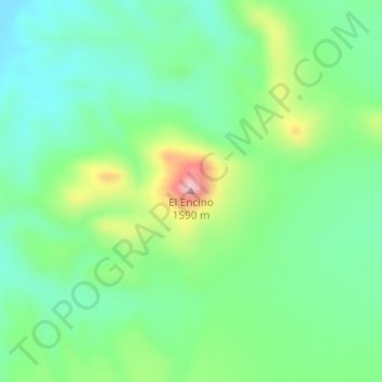
Naam: Topografische kaart El Encino, hoogte, reliëf.
Locatie: El Encino, Satevó, Chihuahua, México (27.86081 -105.84095 27.86091 -105.84085)
Gemiddelde hoogte: 1.459 m
Minimale hoogte: 1.390 m
Maximale hoogte: 1.613 m
Andere topografische kaarten
Klik op een kaart om zijn topografie, zijn hoogte en zijn reliëf te bekijken.
El Palomar
México > Chihuahua > Satevó > El Chamizal
El Palomar, El Chamizal, Satevó, Chihuahua, México
Gemiddelde hoogte: 1.466 m
San Rafael
México > Chihuahua > Satevó > La Cieneguilla
San Rafael, La Cieneguilla, Satevó, Chihuahua, México
Gemiddelde hoogte: 1.438 m
San Jose del Sitio
San Jose del Sitio, Satevó, Chihuahua, México
Gemiddelde hoogte: 1.530 m