
Topografische kaart McArt's Fort
Interactieve kaart
Klik op de kaart om de hoogte weer te geven.
Over deze kaart
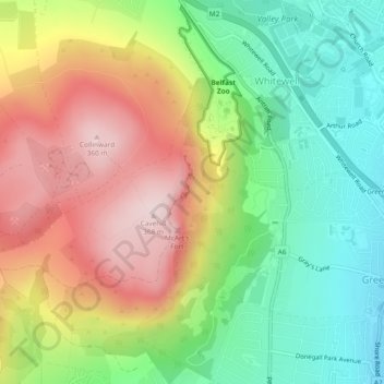
Naam: Topografische kaart McArt's Fort, hoogte, reliëf.
Gemiddelde hoogte: 165 m
Minimale hoogte: 3 m
Maximale hoogte: 364 m
Andere topografische kaarten
Klik op een kaart om zijn topografie, zijn hoogte en zijn reliëf te bekijken.
Ballygomartin
United Kingdom > Northern Ireland > County Antrim > Belfast
Ballygomartin, Ligoniel, Belfast, County Antrim, Northern Ireland, United Kingdom
Gemiddelde hoogte: 258 m
Botanic Gardens
United Kingdom > Northern Ireland > County Antrim > Belfast
Botanic Gardens, Queen's Quarter, Belfast, County Antrim, Northern Ireland, United Kingdom
Gemiddelde hoogte: 15 m
Cavehill
United Kingdom > Northern Ireland > County Antrim > Belfast
Cavehill, Belfast, County Antrim, Northern Ireland, BT36 7PN, United Kingdom
Gemiddelde hoogte: 188 m
Edenderry
United Kingdom > Northern Ireland > County Antrim > Belfast
Edenderry, Woodvale, Belfast, County Antrim, Northern Ireland, United Kingdom
Gemiddelde hoogte: 50 m